Log in
All resources
Create a design
887 Free Artworks of Old Maps Of France
bibliothèque nationale de france
maps of spain by tomas lopez
old maps of castile and león
maps by willem and johannes blaeu
1783 maps of spain
maps from gallica
orientalist painting
1773 maps of spain
marco boschini
guillaume sanson
maps from géographie illustrée de la france et de ses colonies
orientalist painting
maps of spain by tomas lopez
maps of zamora
maps from gallica
old maps of rouen
reconstructions of old maps
german renaissance
cartes de franz schrader
old maps of the alps
reconstructions of old maps
german renaissance
old maps of edinburgh
maps from gallica
maps of spain by tomas lopez
1762 maps of spain
italia - di matteo greuter... - btv1b525056959
17th-century maps of istria
maps of the ganges river
old maps of bengal
châlons-en-champagne in the 17th century
hugues picart
old maps of henan
maps with figures
1660s maps of france
old maps of nevers
novus atlas sinensis
old maps of shanxi
old maps of folegandros
old maps of sikinos
maps by pieter van der keere
old maps of north brabant
cartes de franz schrader
old maps of oran
old maps of nassau
salomon rogiers
maps of ports and fortresses of the mediterranean by marco boschini (1651)
old maps of souda (crete)
old maps of atlantis
island of california
1762 maps of north america
maps by tomas lopez
maps of paris from the david rumsey historical map collection
maps of paris by caspar merian
atlas - voyage pittoresque à l'île-de-france, au cap de bonne-espérance et à l'île de ténériffe (1812) by milbert
maps from the mechanical curator collection
atlas - voyage pittoresque à l'île-de-france, au cap de bonne-espérance et à l'île de ténériffe (1812) by milbert
maps from the mechanical curator collection
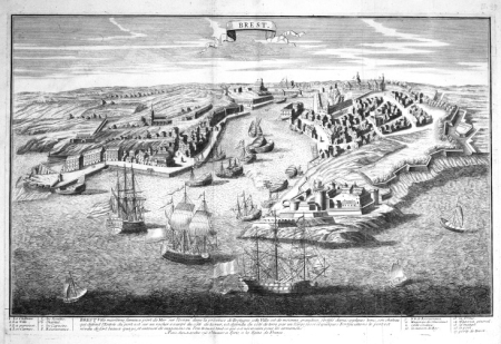
old maps of rade de brest
cartes de franz schrader
18th-century maps of north america
1708 maps of north america
maps by pieter van der keere
old maps of zutphen
maps by pieter van der keere
old maps of flanders
maps of spain by tomas lopez
1779 maps of spain
maps of spain by tomas lopez
1779 maps of spain
maps of spain by tomas lopez
1782 maps of spain
old maps of tenerife
1779 maps of spain
maps of spain by tomas lopez
1779 maps of spain
maps of spain by tomas lopez
1782 maps of spain
maps of spain by tomas lopez
1779 maps of spain
maps of ancient italy by philipp clüver
old maps of the alps
maps by pieter van der keere
old maps of liège (province)
old maps of guizhou
maps from gallica
maps by hendrik hondius the younger
old maps of overijssel
maps of spain by tomas lopez
old maps of gran canaria
maps of cities in venezuela
maps by juan lopez
romanticism,neoclassicism
1852 maps of france
old maps of auvergne
1660s maps of france
old maps of rions
léo drouyn
old maps of rions
léo drouyn
maps by alexis-hubert jaillot
maps by guillaume sanson
old maps of antikythera
old maps of kythira
old maps of the shetland islands
old maps of the orkney islands
cartes generales de toutes les parties du monde (1658)
maps by guillaume sanson
tresor des cartes geographiques (1659)
old maps of the whole peloponnese
old maps of saint-louis (senegal)
orientalist painting
old maps of saint-louis (senegal)
orientalist painting
old maps of farmakonisi
old maps of agathonisi
old maps of norway
guillaume sanson
dessin du château de brest
old maps of brest harbours
old maps of france
old maps of lyon
atlas - voyage pittoresque à l'île-de-france, au cap de bonne-espérance et à l'île de ténériffe (1812) by milbert
maps from the mechanical curator collection
maps of spain by tomas lopez
1774 maps of spain
maps of spain by tomas lopez
1774 maps of spain
maps of spain by tomas lopez
1783 maps of spain
maps of spain by tomas lopez
1783 maps of spain
maps of spain by tomas lopez
1774 maps of spain
maps of spain by tomas lopez
1774 maps of spain
maps of spain by tomas lopez
1783 maps of spain
maps of spain by tomas lopez
1783 maps of spain
maps by thomas kitchin
1781 maps of europe
maps by willem and johannes blaeu
old maps of gâtinais and sénonais
maps of paris from the david rumsey historical map collection
maps of paris by caspar merian
maps from gallica
guides joanne
maps by alexis-hubert jaillot
maps by guillaume sanson
old maps of bourbonnais
1660s maps of france
sixth map of paris from traité de la police
maps of paris from paris musées
old maps of antiparos
old maps of paros
old maps of whole wales (alone)
1640s maps of wales
old maps of the kingdom of naples
lago patria
17th-century maps of savoie
old maps of savoie
prints from manesson travaux de mars at the peace palace library
old maps of brest from musée de bretagne
old maps of atlantis
island of california
orientalist painting
old maps of dakar
maps by hendrik hondius the younger
old maps of gâtinais and sénonais
orientalist painting
old maps of dakar
maps by alexis-hubert jaillot
old maps of the tyrol
old maps of plymouth and devonport
16th-century maps of england
old maps of westphalia
johannes gigas
old maps of vardø
guillaume sanson
maps of spain by tomas lopez
old maps of castile and león
maps of spain by tomas lopez
old maps of extremadura
engravings by frans hogenberg
french wars of religion
maps of spain by tomas lopez
1783 maps of spain
maps of spain by tomas lopez
old maps of extremadura
maps of spain by tomas lopez
old maps of castile and león
maps of spain by tomas lopez
old maps of castile and león
old maps of vardø
guillaume sanson
maps of spain by tomas lopez
old maps of castile and león
maps of spain by tomas lopez
1783 maps of spain
maps of spain by tomas lopez
1783 maps of spain
maps of spain by tomas lopez
1783 maps of spain
maps of brest, france by antoine aveline
brest (france) in the 1700s
18th-century maps of edinburgh-shire
maps of scotland by herman moll
bourbonnais in the 17th century
pierre mariette i
401 - 500 of 887
Next page
/ 9


![[Reproduction of the terrestrial globe (orbis imago) by Jean Stabius, 1515] (Facsimile reproduction)](https://cdn.creazilla.com/illustrations/10000781714/reproduction-of-the-terrestrial-globe-orbis-imago-by-jean-stabius-1515-facsimile-reproduction-sm.webp)

![[Reproduction of the terrestrial globe (orbis imago) by Jean Stabius, 1515] (Facsimile reproduction)](https://cdn.creazilla.com/illustrations/10000450806/reproduction-of-the-terrestrial-globe-orbis-imago-by-jean-stabius-1515-facsimile-reproduction-sm.jpg)


![Port and Forte[z]za d[ell]a Suda / by Marco Boschini, Marco Boschini, 1651](https://cdn.creazilla.com/illustrations/10001359456/port-and-fortezza-della-suda-by-marco-boschini-marco-boschini-1651-sm.webp)


![Queicheu imperii sinarum provincia decimaquarta / [tirée du P. Martini]; Exc. I. Blaeu, 1655](https://cdn.creazilla.com/illustrations/10001381799/queicheu-imperii-sinarum-provincia-decimaquarta-tire-du-p-martini-exc-i-blaeu-1655-md.jpg)


![Treasure of geographical maps of the main states of the universe [...], 1659](https://cdn.creazilla.com/illustrations/10000206928/treasure-of-geographical-maps-of-the-main-states-of-the-universe-1659-md.jpg)


![Sixth plan of the city / of Paris / And its increases, from the beginning of the Reign of Charles / VII, the year 1422, until the end of the Reign of Henry III, the year 1589 [1705], Antoine Coquart](https://cdn.creazilla.com/illustrations/10000442243/sixth-plan-of-the-city-of-paris-and-its-increases-from-the-beginning-of-the-reign-of-charles-vii-the-year-1422-until-the-end-of-the-reign-of-henry-iii-the-year-1589-1705-antoine-coquart-sm.webp)

![Wallia principatus, vulgo Wales. Serenmo Domino Carolo, Magnae Britanniae, etc. principi Joh. Blaeu / [Excudit J. Blaeu.], 1645](https://cdn.creazilla.com/illustrations/10001591803/wallia-principatus-vulgo-wales-serenmo-domino-carolo-magnae-britanniae-etc-principi-joh-blaeu-excudit-j-blaeu-1645-md.jpg)


![Duchy of Bourbonnois / [Pierre Mariette], Pierre Mariette I, 1668](https://cdn.creazilla.com/illustrations/10000233377/duchy-of-bourbonnois-pierre-mariette-pierre-mariette-i-1668-sm.webp)